SHAH ALAM, Sept 27 – The recent revelation in the Rimba Disclosure Project (RDP) that nearly 4,000 hectares of forests in the state of Selangor are under threat has riled up several environmental activists in the state, who have been calling for transparency and accountability in the matters related to forest and land management in the state the last two years.
From the proposed agriculture park in a peat swamp forest to issuing new licenses for RM2 companies for quarry operations and deforestation of sensitive areas for property development and sales of forest land, the state’s earlier pledges to protect the forests and environment, have become highly questionable, said an activist.
These plans, which cover the various districts of Selangor from Sabak Bernam, Selayang, Ampang, Kuang, Sungai Buloh, Serendah, South Kuala Langat Forest areas to Genting Highlands are also said to eroding into the Orang Asli areas.
Calls for a town hall meeting on several deforestation hotspots in the state have not been entertained, while attempts to meet the related member of the Selangor State Executive Council have not been successful, and any written letters requesting for information have been met with the reply of “Matter is under the Official Secrets Act”, said one activist.
“The forest department has also not replied to some of my queries,” said Otai Reformasi Secretary Abdul Razak during a zoom conference call with Weekly Echo.
Scientist Dr Teckwin Lim who was also on the call said the report was a reflection of the growing failure of the state to fulfill the pledges of deforestation and that under the Select Committee for Competency, Accountability and Transparency (Selcat).
He also wanted to know how the state will fit in the new quarrying activities, which will involve the clearing of forests, with its moratorium on logging.
In its report published Sept 14, the RDP authors said the primary threats to Selangor’s forests included projects already known to the public and new data sighted by the RDP.
“Our data has found that 3,953.22ha of forests are to be potentially cut down in the near future. These forests sequester 16,986 tonnes of CO2 a year (based on our carbon accounting methodology), regulate temperatures in Selangor and provide soil stability which reduces the risk of flooding and landslides. Further, these threatened forests highlight a number of issues, including legal inconsistencies, non-transparency, biodiversity loss and potential encroachments of indigenous lands.”
Among the projects are the Selangor Smart Agro Park in a peat swamp forest.
This project by the Selangor State Agriculture Corporation (PKPS), will see 971ha of peat swamp forest in Sabak Bernam cut down for mixed-agriculture.
Citing research by Sahabat Alam Malaysia, the report said the area in question is an intact, high-quality forest harbouring various endangered species, and it has been designated as an Environmentally Sensitive Area (ESA) under the National Physical Plan 3.
Peat swamp forests are also among the most carbon-intensive ecosystems in the world.
In September 2021, the project was halted by the Department of Environment as an Environmental Impact Assessment (EIA).
However, PKPS has stated that they “remain committed to implementing the SSAP project based on the laws and regulations set by the Selangor government”, indicating that the project will eventually go ahead.
Based on Global Forest Watch (GFW) data, this area sequesters 2820t of CO2 per year.
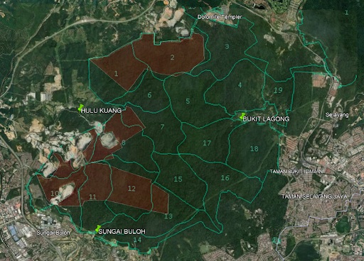
Then there are plans for quarries in Bukit Lagong Forest Reserve.
“During investigations into the sale of land within Bukit Lagong Forest Reserve, the RDP sighted this “Pelan Kawasan Kuari”, published by the Jabatan Perhutanan Negeri Selangor, on a listing on EdgeProp. This plan shows that a significant portion of the forest reserve appears to have been parcelled out to private companies for quarrying. Using georeferencing, we have identified that the portion of area in question that is still forested is roughly 887ha in size.
“Using satellite analysis, we have found that this forested area is still an intact, high quality forest which has not seen any degradation since before 1985. Furthermore, the quarry areas are less than 1km from two Orang Asli villages (Hulu Kuang and Sungai Buloh) and it could potentially impact their customary land rights as well (see appendix).
“We are unaware of any environmental impact assessments done for these quarries, except for the parcel owned by The Greatest EcoPark Holding Sdn Bhd (40ha).”
According to the report, it was also the first time that the quarry plan had been released to the public, indicating a total lack of transparency on the part of the Forestry Department.
Under GFW, the area sequesters 1692t of CO2 per year.
Other proposed plans reported in the RDP include the sale of forested land in Serendah for residential and commercial development.
“Using georeferencing, we have found that the area in question is still an intact forest, that the land goes up to an altitude of over 500m and there are slopes in the area with a steepness of in excess of 50 percent.”
The ongoing issue between environmental groups and the state on the Bukit Cerakah Forest Reserve was also covered in the report.
According to the report, the degazettement of 406 hectares of Shah Alam Community Forest on May 5th this year was not done in conformance with Selangor forestry laws, which mandate that a public hearing is required before any degazettements.
The degazettement was backdated to November 20 2000, posing legal inconsistencies.
Since then, Shah Alam Community Forest and PEKA have applied for a judicial review of the degazettement. On 11 August 2022, they received a stay order against the degazettement. The overall decision of the review remains to be seen pending the legal process.
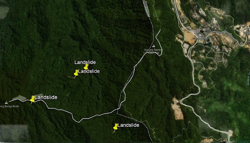
The report also highlighted the zoning of forested land in Selayang for non-forest usage, the development of forest areas in Ampang, and the proposed development plan near Genting Highlands which will include a new road to the peak of Gunung Bunga Buah (1430m), a mountain opposite Genting Highlands, and the development of the area around the peak.
Other plans include developing the relatively flat areas on the Selangor side of Gohtong Jaya, which consists of mostly intact forests.
The proposed new roads and development of the area to the north of the road from Gohtong Jaya to Genting Highlands will be a mostly contiguous development on the side of the mountain from elevations 954m to 1700m.
There are plans to extend the road on the Ulu Kali ridge by around 4km due north, and developing areas along this proposed road, which consist of intact mossy forests.
“This raises a number of biodiversity concerns. The Ulu Kali ridge is home to highly endemic species.”
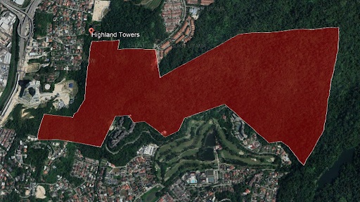
On the development of forests in Ampang, it highlighted that during the public consultation process of the Draf Rancangan Tempatan MPAJ 2035, the forested hills behind Taman TAR in Ampang had been proposed to be zoned for development.
)
“It was also found that some of the land is potentially currently already owned by FINAS, and that the process of commencing development of that land has already begun. These findings were published on the Facebook page: “Ukay Heights Commuter”.
“The draft plan identifies this area as having a high disaster risk in terms of landslides. Indeed, part of the area borders the Highland Towers site.”
The report also highlighted the agriculture plans in South Kuala Langat Forest Reserve, which is a peat-swamp forest that holds high carbon-intensive ecosystems, that sequesters roughly 1089t of CO2 per year (based on the assumption of degraded forest).
Other plans that pose serious environmental hazards include the sale of a forested land in Pulau Indah, which is an intact mangrove forest and the development of mixed agriculture in Sungai Karang Forest Reserve.
The RDP authors said they have sighted a Facebook post alleging that 1000 acres of forest reserve in Selangor had been given to Koperasi Usahawan Bersatu Selangor Berhad (KUBSB).
“Attached to that post is an image of a letter allegedly sent by that company to the Department of Environment requesting permission to construct drainage infrastructure in compartments 2, 3 and 4 of the reserve.
“The RDP investigated and found a report of an AGM held by KUBSB on 6 August 2022. This report indicates the existence of an EIA entitled: “Cadangan Pembangunan Pertanian Bercampur di Tanah Hutan Simpan Sg. Karang Sabak Bernam, Selangor.
“The report alleges that the EIA was approved on 23 March 2022. This EIA does not show up on the DOE website to the best of our knowledge.”
The RDP report said it had highlighted the largest threats to Selangor’s forests above a 100ha threshold.
The full RDP report is available here.
The Rimba Disclosure Project (RDP) is an independent, non-political forest monitoring watchdog which aims to create transparency by being a centralised source of data and investigations on forest loss in Malaysia.
— WE
Related reports by WE:
The State of Sarawak Map:
https://www.weekly-echo.com/wp-admin/post.php?post=3901&action=edit
Bukit Cherakah
https://www.weekly-echo.com/wp-admin/post.php?post=7013&action=edit