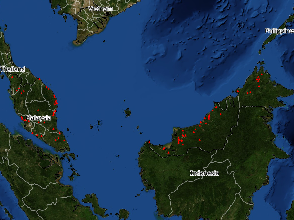
SUBANG JAYA, June 22 – There were a total of 114 fire or hot spots in Peninsular Malaysia and Sabah and Sarawak this past week as shown by the data available on the NASA’s Earth Observing System Data and Information System.
One of the fires at coordinates 4.136 Latitude and 102.350 Longitude, is still ongoing at a place close to the Tembeling River in Pahang, where a proposal to carry out mining has been wrought with some controversy.
The Department of Environment has put on display the information to access the Environment Impact Assessment (EIA) report for the proposed Iron Ore Mining Operation on Lot 15523, covering an area of 60.75 hectares in Kuala Tembiling in Jerantut, Pahang May 31st this year.
It will be displayed until June 29 for the public to make their comments and so on before any further progress is made to the plan. However, this could be extended considering that the period for feedback is during the MCO, where people are not able to travel and check out anything before giving their feedback.
For naturalist Andrew Sebastian, while feedback from the locals will be given priority consideration, others with interest in the protection of environment and so on should also be given the chance to give their feedback.
He also said that for such a proposal to be there in the first place made no sense at all.
The area itself is a high biodiversity area and a key entrant point to the country’s National Park or Taman Negara, where the government has invested heavily to ensure protection of the country’s forest and natural wildlife, he said.
The impact of mining, which will leave nothing behind, where the forest will have to be cleared and with it, the wildlife and so on, will bring about huge damage to the ecosystems there, he said.
He also called on a greater transparency in the process of EIA approvals. Right now, there is no way of knowing what is the outcome of feedback given to an EIA as sometimes projects go ahead even when the EIA have pointed out significant damages a particular project can bring.
Meanwhile, a call made by Weekly Echo to DOE to know more details or even confirm the fire hot spots as captured by the satellite images were met with very little information as the department has been experiencing a technical problem with its lines this past week.
However, the department has been regularly issuing stern warnings to those conducting open fires or burning.
-WE